Last updated February 6, 2005
Photos taken on January 9 and 10, 2005. Weather conditions were very cloudy and foggy until we reached the Davis Mountains in west Texas.

Eastbound on Interstate 410 in San Antonio, approaching Interstate 10 north.

(Click for high resolution)
Eastbound on Interstate 410 at the Interstate 10 interchange.
Progress is very slow on this construction project. Four years ago construction was already well-underway.
I think this is a multiphased project and the last phase is finally in progress.

A ramp at the I-410/I-10 Interchange.

Westbound on I-410 in south San Antonio at the I-37 stack interchange. This is a 1960s-era stack
with old school design.

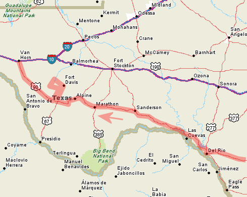
We proceeded west from San Antonio on US 90. The freeway ends about three miles west of I-410 and becomes
a 4-lane divided highway for the next approx. 60 miles to Uvalde. The landscape was surprisingly nice
along this section of highway - lots of irrigated farms and also a significant presence of nice oak trees.
Of course, things become drier as you move west, and west of Uvalde the landscape started to rapidly
degenerate into a grim landscape of brush and scrub. This photo shows the INS checkpoint between Uvalde
and Del Rio.

After an overnight stop at Del Rio, we awoke to very dense fog. Visibility was about 100-200 meters. Needless
to say, photography was out of the question. Lake Amistad and the Pecos River bridge are just north of town.
Since the river is in somewhat of a valley, fog was lighter and the bridge was visible.

A view from the water level. Notice that the water has engulfed nearby brush. Water levels shot
up substantially in late 2004, ending a 10-year run of very low lake levels.
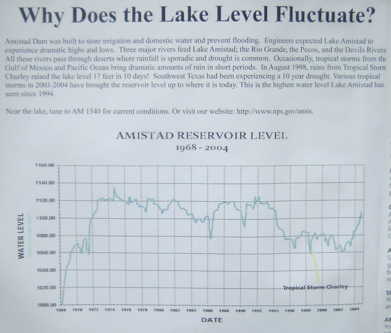
This plot shows how lake levels have risen recently, about 50 feet above the all-time low in 2002.

A view of the Pecos River canyon, showing more flooded brush.


The historical plaque and TxDOT sign.

North of the lake US 90 runs close to the Mexico border. We are now out of brush country and in
a grim desert zone. There are dirt roads along both sides of the
paved highway. INS patrols cruise on the dirt roads (shqwn above).

The 75 mile per hour speed limit begins in Terrell County. 75 mph speed limits are available in counties
with low population.

Here is another 75 mph sign.

Elevation increases gradually and reaches 4481 feet at Alpine. This is not quite the Swiss Alps.

A view between Alpine and Marfa. The terrain here is typical range that you'll find at moderate elevation
throughout most of the western United States, especially Arizona.

At Marfa we detoured from US 90 to visit the Davis Mountains. This is the Presidio County courthouse at
Marfa on Route 17.

This is a typical view on Route 17, showing the desert rangeland.

(Click for high resolution)
This fork in the road is in Fort Davis at the 17/118 split.

(Click for high resolution)
This is a view of Fort Davis, a partially restored 19th century frontier outpost.
It's an interesting visit if you're in the area, but nothing too exciting. You wouldn't want to go too
far out of your way to see it. There is a nice hiking trail along the ridge in the background.

Another view of Fort Davis ruins. There are many more structures at the site that are fully restored.

(Click for high resolution)
Highway 118 leading to the MacDonald Observatory in the Davis Mountains, which is operated by UT-Austin.

Another view on 118 approaching the observatory center.

The observatory is at 6791 feet, the highest point on the Texas highway system.

This is west of the observatory, on route 118 or 166 (can't remember exactly where). This is a very
desolate area.

Another view west of the observatory, on route 118 or 166.

This is highway 166 in a mountainous zone. Overall, I wasn't too impressed with the Davis Mountains.
Elevation just isn't high enough to support forest growth, so it is mostly a desert zone with
some juniper and scrub. You'll find much nicer landscapes in Arizona or Utah.

We returned to US 90 at Marfa and then continued westward to our stopping point at Van Horn.
This view looks northward on US 90 toward Van Horn and the intersection with Interstate 10.